For better user experience, please use another browser.
Golden Stream Corridor Preserve
Improved protected area management through the bolstering of Ecotourism Belize’s (ETB) sustainability and impact through investment in equipment and infrastructure.
Shared local indigenous culture and supported Golden Stream Corridor Preserve (GSCP) buffer communities through innovative ecotourism initiatives.
Ya’axché Conservation Trust’s social business initiative, EcoTourism Belize (ETB) facilitates sustainable ecotourism to local and international audiences, of which the proceeds are directly reinvested into conservation and community development across southern Belize. This project focuses primarily on boosting natural and cultural ecotourism offerings within Golden Stream Corridor Preserve (GSCP), Ya’axché’s private protected area, and the surrounding buffer communities.
Through this project, a new restroom facility will be constructed and the current bunkhouse providing visitor accommodations on the grounds of GSCP’s ranger station will be updated and improved through new paint, ceiling fans, bed linens and furnishings, as well as through the addition of a screened veranda. To increase the diversity of available lodging and appeal to a wider audience, two tents will be purchased to provide camping opportunities within GCSP. The visitor grounds will be further improved through the installation of directional signs indicating visitor facilities. Ecotourism offerings which allow visitors to experience GSCP and the intact ecosystems protected by the Preserve will be enhanced through the purchase of kayaks, canoe paddles and binoculars, and GSCP’s self-guided nature trails will be demarcated with new signs for ease of visitor use. To provide convenient transportation from guest accommodations to tour sites, a tour van will be purchased.
In addition to the GSCP-based ecotourism activities offered, ETB partners with local indigenous women’s groups so that they can share their cuisine, crafts, music and Maya culture with interested visitors. Therefore, this project provides capacity building for these women through workshops focused on hospitality and customer service.
The livelihoods of many buffer communities are highly dependent and rely on the land, water and biological diversity found locally. Ecosystem services provided through Ya’axché’s ability to safeguard Golden Stream Corridor Preserve (GSCP) include clean water and air, game species, flood control, pollination and non-timber forest products. Through investment in capacity building, infrastructure and equipment, Ecotourism Belize (ETB) will develop consistent and environmentally responsible tourism programs, empowering local indigenous women and communities and leading effective biodiversity conservation of Golden Stream Corridor Preserve (GSCP) and the larger Maya Golden Landscape (MGL). This will allow ETB to emerge post-Covid-19 in a strong position, for the first time, to generate consistent income for Ya’axché’s conservation and development initiatives across southern Belize’s protected areas.
Through infrastructure investment within GSCP, two zones (Zone 1 for General Use; Zone 2 for Education and Recreation) demarcated in the PCA’s management plan will have improved infrastructure and sustainable access for visitors, allowing ETB to reach a larger population of visitors and elevating the visitor experience. Furthermore, through ownership of equipment, ETB’s ecotours within GSCP will no longer hinder patrolling or field research, allowing for more effective protected area management.
Download the project infofiche.
Ya’axché Conservation Trust
1-mile San Antonio Rd. Toledo, Belize C.A.
Improved management effectiveness and governance indices at the end of action by 2023
This project will address the following objectives based on the protected areas associated with the project:
The implementation of this project will bring significant positive change for the protected areas (Gladden Spit Silk Cayes Marine Reserve, Sapodilla Cayes Marine Reserve including the Cayman Crown Site and the Port Honduras Marine Reserve) associated with the project. Foremost, by providing information on spawning aggregation sites and engaging local actors for their protection: Policies will be put in place, in countries where this is necessary, for the full protection of spawning aggregation sites or temporary protection during spawning seasons; the law will be applied during spawning periods in spawning sites, not only in already protected areas but also in new areas proposed at Cayman Crown; local fishermen will adhere to no-fishing guidelines according to the rules set out in the spawning aggregation sites; and the number of fish documented in these areas during the spawning period will be stable or increase for all species.
Download the project infofiche.
Toledo Institute for Development and Environment (TIDE)
Belize Southern Environmental Association and Healthy Reefs for Healthy People
Three Bays Marine Protected Area, Haiti
Haiti’s marine protected areas are relatively new, with all having been declared after 2013. With either no, or at best, extremely limited resources available, this project will address a critical need to increase capacity (human and equipment) to monitor and manage resources within the MPA as well as address the need to provide environmentally friendly and sustainable alternative income generating opportunities for local stakeholders in order to enhance local management of the marine protected area.
In order to complete project objectives members of the Agence Nationale des Aires Protégées (ANAP), FoProBiM, and local university students will be trained in environmental sciences, coastal and marine resources and basic biology, non-lethal (un-armed) environmental law enforcement engagement, laws relating to coastal and marine resources and marine protected areas, and how to operate various types of equipment (boats, motors, snorkelling, and communications equipment).
FoProBiM will provide training to 20 local stakeholders in apiculture as an alternative livelihood and provide them with 100 hives and apicultural equipment in order to begin honey production.
Without this project the opportunity to provide a presence throughout the marine protected areas through the training of human resources within ANAP, the Gad Ekolojik, FoProBiM, local Universities, and the local communities to begin to ensure proper and sustainable monitoring, surveillance, educational and enforcement activities would remain severely limited, if not non-existent. All of these groups will be provided a total of 10 days of training: 2 days each of environmental; non-lethal (un-armed) environmental law enforcement engagement and laws; how to operate various types of equipment; “water” classes (snorkelling, swimming, etc.), and; field work including wildlife ID, boat patrols, hiking, etc.). To support the development of presence throughout the MPA the acquisition of equipment to strengthen both ANAP’s and FoProBiM’s capacities to undertake surveillance, monitoring, research, and enforcement activities by increasing their mobility is a crucial component of this project. Without this presence, and the increase in surveillance it affords, the continued illegal and unsustainable exploitation of resources would continue. The second component of this project is the continued development and strengthening of environmentally friendly and sustainable non-extractive income generating apiculture with 2 local communities and 2 associations to provide livelihood generation in order to reduce unsustainable resource extraction while protecting biodiversity.
Download the project infofiche.
Fondation pour la Protection de la Biodiversité Marine (FoProBiM)
Portland Bight Protected Area
The objective of this project is to use the METT-4 process to identify priority actions for the PBPA using an adaptive management approach that assesses the threats and the effectiveness of previous management actions quantitatively, through data analysis and seeks to identify and address potential and actual risks.
The Portland Bight Protected Area is managed on behalf of the Government of Jamaica by the Caribbean Coastal Area Management Foundation, which leads a coalition of other government agencies that have various responsibilities within the area. The management plans for the PBPA was developed using participatory processes, but it is needs to be updated as it covered the period 2013-18.
The Government of Jamaica also requires protected areas to carry out annual METT assessments but there is no specific mechanism to link METT assessments to management and operations plans. METT assessments are carried by multi-agency teams but are based on qualitative rather than quantitative assessments. METT assessments for the PBPA as a whole were carried out as follows: in 2015, 2018 but no METT was done in 2020.
The new METT-4 methodology provides an approach that could incorporate monitoring data in an adaptive management framework. The recent development of the METT-4 process, provides an important opportunity to bridge the gap between the METT, adaptive management and the updating of management plans. The requirement to use quantitative data offers the opportunity to enhance the METT approach and implement the adaptive management process.
Large amounts of monitoring data have been collected for the PBPA by the various management partners but these data have not been collated, stored in an accessible format, analysed or applied. This project will provide a very important opportunity to gather and analyse the data and for the agencies to work collaboratively to develop practical and measurable management recommendations that can be incorporated in new management plans. The approach developed through this project will establish the procedures to be applied in the future.
The METT-4 would support the preparation of new management plans and the streamlining of the monitoring programme. It would be packaged into an attractive and readable “State of the PBPA 1998-2021 Report” which would be used to promote our work, to support operations planning and to leverage funding.
The project will greatly enhance the conservation of the PBPA, through supporting adaptive management and conservation planning. The collation and analysis of data from multiple sources will improve and adapt the METT process for the PBPA. This will ensure that the METT4 assessment for 2022 will include a better reflection of the work that has been done and the actions needed to improve conservation programmes. The process of obtaining and collating data will strengthen partnerships. It will allow C-CAM to identify gaps in monitoring programmes and to make recommendations and seek funding to ensure that monitoring efforts are targeted towards the most significant adaptive management targets. The results of the METT will inform a revised PBPA management plan, which is being developed under another project. The State of the Portland Bight Environment Report will showcase the work of C-CAM and its partners in the PBPA. This will increase engagement of stakeholders and will support project development and funding.
Download the project infofiche.
Caribbean Coastal Area Management Foundation
• Aripo Savannas Strict Nature Reserve, Long Stretch Reserve
• Matura National Park, St. David Reserve and Eastern Extension Matura
• Nariva Swamp Managed Resource Protected Area
Small Technical Grant for Assessment for improved protected areas management and governance (STGA)
To identify or update result-oriented priority actions for improved protected and conserved areas management and governance, through new or updated quantified management and governance assessments and their associated enhancement plans.
Consultants will, for each protected area:
The project’s implementation will facilitate the establishment of a framework for a quantitative assessment of the status of the three (3) Environmentally Sensitive Areas, with the aim of improving their management. Outputs from the METT-4 assessments will focus different state bodies and other stakeholders on priority management actions and help develop opportunities for inter-agency cooperation to achieve management goals.
Download the project infofiche.
EMA – Environmental Management Authority
• Wallings Nature Reserve
Small Technical Grant for Assessment for improved protected areas management and governance (STGA)
Enhancing protected area management
The METT tool will assist the team to better manage the reserve. There will be better collaboration between Wallings Nature Reserve and key stakeholders and government agencies and the creation of a priority action plan for the next five years for the activities to be implemented by the management team at Wallings Nature Reserve.
Download the project infofiche.
Wallings Nature Reserve
•Miguel Domingo Fuerte Natural Monument
•Parque Nacional Sierra Martín García
•Parque Nacional Francis Caamaño
•Parque Nacional Anacaona
•Refugio de Vida Silvestre Laguna Cabral
•Monumento Natural Pico Diego de Ocampo
•Reserva Científica Salcedoa
•Reserva Científica Quita Espuela
•Reserva Científica Guaconejo
Enhance the management and governance of priority areas by addressing existing limitations (supporting new PAME/PAGE assessment tools, strengthening on-site infrastructure/equipment for patrolling, poaching control, developing capacity of staff).
We are looking to obtain an analysis based on this STGA that clearly and objectively provides the priorities for action to improve the management and governance of these protected areas, and the performance of current management mechanisms. We will identify the priorities to maintain management effectiveness in the medium and long term and determine opportunities for improvement, such as strengthening the relationship with the communities and promoting the sustainable use of resources. We will also analyse the potential environmental and social risks for the implementation of the actions. This analysis will also serve as input for: i) updating or preparing management plans for these protected areas, as appropriate; ii) inclusion of stakeholders in management committees; iii) highlighting the importance of proper management and achieving commitments with decision-makers: iv) obtaining inputs and identifying priority activities for fundraising; v) promote actions with the REDD + Program.
The updated METT Assessments will help determine priorities for action that will be used to improve the management and governance of protected areas and the performance of current management mechanisms. This analysis will also serve as input for: i) updating or preparing management plans for these protected areas, as appropriate; ii) inclusion of stakeholders in management committees; iii) highlighting the importance of proper management and achieving commitments with decision-makers: iv) obtaining inputs and identifying priority activities for fundraising; v) promote actions with the REDD + Program.
Download the project infofiche.
SOH Organización
Rugezi Burera Ruhondo Ramsar Site, Wetland of International Importance; 109095
R-METT (Ramsar Site Management Effectiveness Tracking Tool)
The project will address the following priority needs:
• To enhance the role of local communities in the protection of Rugezi Marsh and its iconic Grey Crowned Cranes, with the ultimate goal of building their sense of ownership so that they can play a greater role in managing the marsh, ensuring its sustainable use , and protecting biodiversity and,
• To improve the protection of Rugezi Marsh and law enforcement so that illegal activities are reduced, and the Grey Crowned Crane population is able to recover.
This project will implement a range of activities to address conservation problems, while engaging and involving community members in the management and protection of the Marsh. RWCA will recruit and train additional Community Rangers at Rugezi Marsh to carry out patrols, report illegal activities, educate community members and monitor populations of Grey Crowned Cranes and breeding activities. Community campaigns and other educational events will be organised to raise awareness among community members about key conservation messages. The team of Marsh Rangers also increase awareness by educating community members during their patrols. The project will involve community members in conservation actions including the restoration of two islands within the Marsh planting 6 000 indigenous trees. There will be opportunities for paid work for community members to plant the trees. RWCA believes in the idea of ‘growing trees’ rather than just ‘planting trees’ so communities will also be involved in follow up activities. Additional activities will work to strengthen law enforcement through workshops with local leaders, joint patrol exercises with stakeholders, organising meetings of the Inter Agency Committee for Illegal Wildlife Trafficking and a workshop for police and other agencies introducing the new wildlife law in Rwanda.
Rugezi Marsh is a Ramsar protected site of international importance and this project will bring about a number of key changes to improve its management and protection. Engaging and involving communities in the management of the Marsh will increase its protection in a sustainable way. As RWCA strengthens its team of Community Marsh Rangers, this will reduce the number of illegal activities t hat take place around the Marsh. Education is key to engaging communities and changing attitudes towards conservation issues. As the project raises awareness, communities will show increased knowledge of conservation issues which will increase their collaboration and involvement in the management of the Marsh. Additionally, increased protection will come from the strengthening of law enforcement efforts which will also reduce the risk of illegal trade of Grey Crowned Cranes. Information gathered about Rugezi Marsh will be shared with international stakeholders and databases which will help to improve and develop management plans. Overall, as a result of the holistic approach that targets the problem from many angles, the result will be an increase in biodiversity and an increase in the population of Grey Crowned Cranes at Rugezi Marsh which will be a good indicator of the health of the ecosystem.
Udzungwa Mountains National Park (UMNP), Tanzania
To maintain livelihoods and/or enhanced resilience of local communities to major shocks caused by COVID pandemic, whilst effectively contributing to protected areas management.
Livelihoods of local communities
The implementation of the project will bring a lot of change not only to the Udzungwa Mountains National Park but also to the local community at large. Through this project the number of tourists in the Park will significantly increase since the nature trails and drive routes in the Park will be easily accessible, poaching and other illegal activities in the Park will be reduced due to increased number of patrols that will be conducted by the Park Rangers, also the awareness of the local community concerning the importance of biodiversity conservation at the Park will be increased. Based on the aforementioned change expected to be seen in the Udzungwa Mountains National Park the project will also contribute to the improvement of livelihoods and resilience of local communities through various conservation activities that will require the involvement community members such as management of drive routes and nature trails.
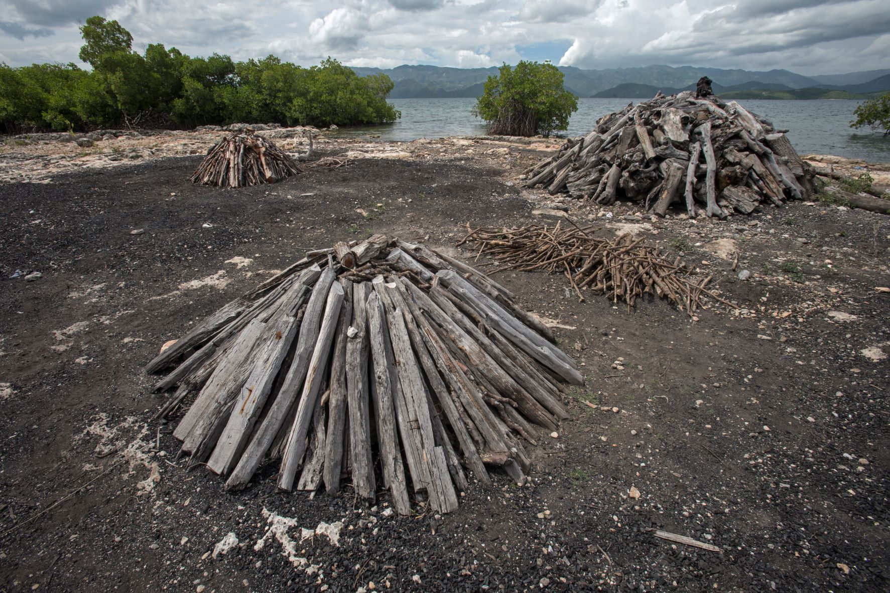
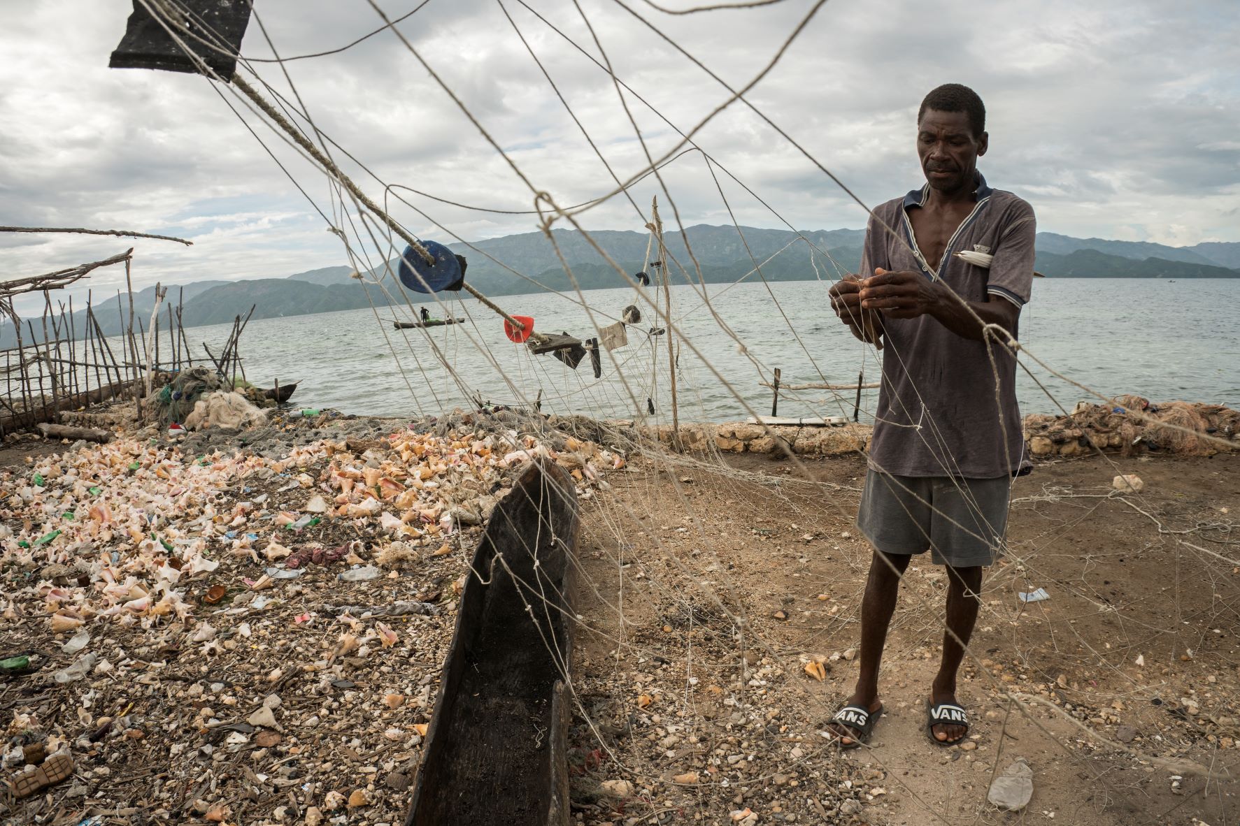
Baraderes-Cayemite Managed Natural Resources Protected Area
Enhance the management and governance of priority areas
There is a critical need to sensitize the communities within the Baraderes/Cayemite Marine Protected Area (MPA) on the importance of preserving their natural resources, restoring, and better managing critical habitats, encouraging the sustainable use of the natural resources, and exploring other income-generating opportunities that will support the lives and well-being of Haitians impacted by COVID-19 long term. The proposed interventions to be carried out will be monitored and measured collectively by stakeholders to show positive conservation impacts to people and nature. If these issues are not tackled in the immediate future, there will be irreparable damage and lasting negative impacts on biodiversity in the area.
The project will first aim to increase marine education and awareness and local capacity by conducting seminars and trainings in the fishing communities. Trainings will focus on the importance of protecting the ocean and coastal resources, marine life including endangered marine species, the benefits these resources provide, and mangrove restoration and management. We will distribute fishing closed season calendars and brochures which describe conservation rules and regulations for the MPA.
The project’s efforts will support improved management of the MPA and it natural resources by training locals in data collection, effective management measures including proper handling of critical species, marine habitat, and species protection, and sustainable fishing practices.
Local fishers will be trained in boat outings to various sites where they will be part of a monitoring network of high-priority species (marine mammals, sharks, sea turtles, stingrays). This network provides opportunities for fishers to assist with the documentation of areas where fishing-related activities are causing the most harm to these species. We will work with the government to ensure our efforts align with the government’s goal to better manage and protect marine biodiversity and to sensitize beneficiaries and local decision-makers on natural resources management and governance reinforcement.
The overarching goal is to increase knowledge relating to marine megafauna ecology and conservation issues throughout communities to address and establish realistic management regulations and provide data for policymakers and future management, thus helping to reduce pressure on local populations. Our goal is to protect and restore mangroves, which have immense value to local communities while developing a solid community resilience plan. This will not only create opportunities for the community members to learn and be engaged but also for them to feel a sense of ownership, to encourage and promote long-term continuity and preservation of the gains from this project. We would set up an ongoing program involving marine education/outreach activities so community members of all ages and fishers are trained and engaged in conservation work to ensure positive impacts are lasting.
Through these conservation initiatives, we will acquire valuable data and information and document any lessons learned. Completion of these activities will provide a clear understanding and overview as to how to effectively manage this area, and how to derive sustainable, biological, social, and economic benefits from this renewable aquatic resource. These activities will include the importance of community engagement to ensure effective and long-lasting conservation impacts.
Download the project infofiche.
Initiative pour L’Environnement Intégré en Haiti
Fondation Haiti Ocean Project