For better user experience, please use another browser.
Iwokrama Protected Rainforest Area
Increased resilience to major shocks and recovery of the protected and conserved areas including sustainable/innovative funding planning.
The project intends to interview stakeholders from the Iwokrama Protected Forest Area which include indigenous community and staff of an Eco-Lodge in the protected area to identify how the COVID-19 pandemic have impacted their operation and livelihoods within the protected area. The information gathered will then be used to prepare an Eco-tourism recovery manual from the COVID-19 pandemic, scientific manuscripts to be submitted for peer review to international journals and several reports to be shared with the stakeholders of Iwokrama and the wider tourism sector of Guyana. The project will also enhance the promotion of Iwokrama through digital media advertisements and online platforms. The entire project will culminate with a tourism stakeholder’s conference where all the project findings will be shared to the larger tourism sector of Guyana.
The Iwokrama Protected Area is a unique case study site that demonstrates the benefits of an effective eco-tourism model that enhances conservation efforts. The challenges presented by the COVID-19 pandemic are unique to the eco-tourism industry in general as the level of travel restrictions imposed globally was unprecedented. The eco-tourism operations in Iwokrama was not prepared for the measures taken to alleviate COVID-19 which has impacted the operations of its conservation efforts and the livelihoods of numerous indigenous communities. The change the project will therefore bring to the protected area is in better preparing the eco-tourism operation of Iwokrama for future pandemic circumstances similar to COVID-19 by understanding how the COVID-19 pandemic affected current operations.
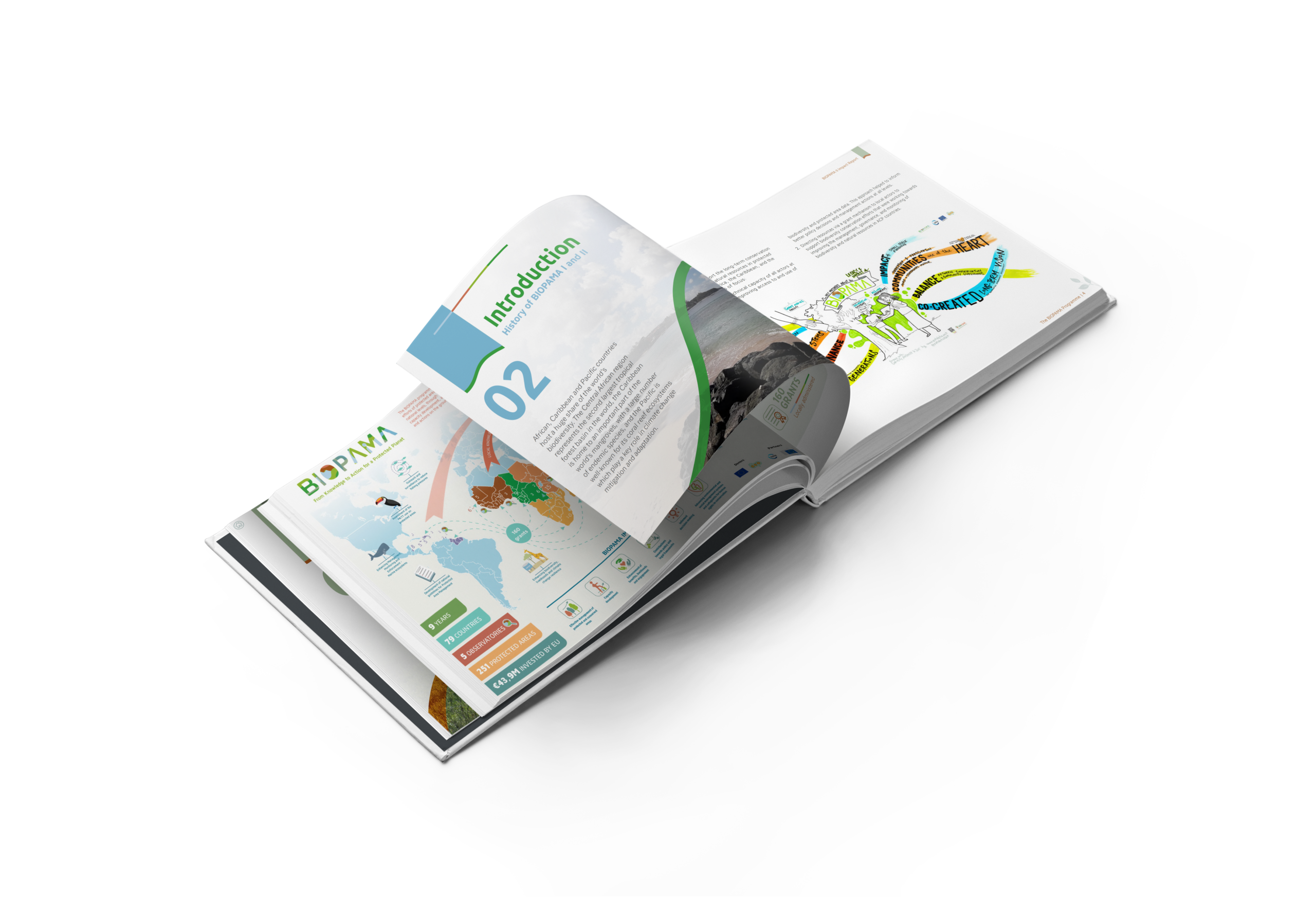
Download the project infofiche.
Faculty of Earth and Environmental Sciences, University of Guyana
Savannes Bay: Pointe Sable Environmental Protection Area (PSEPA)
Enhanced management and governance of protected or conserved areas.
Enhanced management and governance of protected or conserved areas
Project funding will support piloting of governance and capacity building measures intended to improve the effective management and sustainable use of coastal and marine resources. In the main the project scope will address issues related to the use of coastal and marine resources within a protected area, that includes potential user conflicts; deterioration of coastal and marine habitats and unregulated and unsustainable practices. The project will also contribute to the long-term goal of effectively managing resources and resource users and supporting the sustainable livelihoods within the PSEPA. These include:
This project will improve management and governance of Savannes Bay’s natural resources through interventions that regulate and promote sustainable livelihoods through sustainable use of resources within the protected area including zoning and the certification of seamoss farmers. It is envisaged that the project activities will help to:
Download the project infofiche.
Saint Lucia National Conservation Fund
Department of Fisheries
Parc National Foret des Pins, Boucan Chatte
Maintained livelihoods and/or enhanced resilience of local communities to major shocks caused by COVID pandemic, whilst effectively contributing to protected areas management.
After COVID-19 was detected in Port-au-Prince, Haiti, many citizens returned to Boucan Chatte; a village located in the buffer zone of the Forêt-des-Pins National Park. The returning citizens cleared forested areas for agricultural use thereby accelerating rates of environmental degradation in the region. These unsustainable agricultural practices threatened the primary forest that provides habitat for the critically endangered Black-capped Petrel (BCPE). The project aims to address the need for improved agronomic techniques and enhanced environmental awareness to reduce deforestation and land degradation which threaten biodiversity.
To reduce forest degradation and protect the critically endangered Black-capped petrel (BCPE), the project activities will include training in sustainable agricultural practices to local farmers associations, teaching environmental education in local schools, building two community tree nurseries, and enhancing research and conservation of the BCPE.
The project is implemented near the Forêt-des-Pins National Park providing locals with the opportunity to work as part of an association that provides farmers with access to loans and savings, obtaining skills in land restoration and sustainable agricultural practices. This will reduce deforestation for agricultural expansion. It is envisaged that with the construction of three tree crop nurseries farmers will have the capacity to continue restoring degraded areas.
Additionally, the project will provide the opportunity for field staff researchers to identify additional BCPE nest cavities and better understand drivers and cause of the species decline in the community and potential measures to mitigate against threats. Furthermore, the environmental education subjects taught in local schools will help kids to develop a passion to protect their environment.
Download the project infofiche.
Action pour la Sauvegarde de l’Ecologie en Haïti (ACSEH)
Environmental Protection in the Caribbean (EPIC) and Plant With Purpose
Chumbe Island Coral Park
This project will address three priority needs of the protected area:
Chumbe Island Coral Park is a not-for-profit private marine and terrestrial protected area in Zanzibar, Tanzania. Funded entirely by sustainable ecotourism, the park has been self-financing for more than 20 years. Due to COVID19 however, tourism came to a complete standstill in 2020 and is still nowhere near to pre-Covid numbers. We have had to put 29 out of 41 staff on unpaid leave and the remaining 12 staff have been working fulltime on a reduced salary to keep the park protected during these difficult times. This project will fund the salaries and patrol costs of the conservation team to keep the island protected and secure from poaching threats.
The following project activities will ensure that conservation management on Chumbe Island will continue, despite the fact that the eco-lodge still has limited to no bookings, and address the urgent threat on the marine park, Chumbe staff and local fishing communities:
Most importantly, project implementation will allow for full patrol operations over the coming 12 months which will decrease poaching attempts inside the MPA and subsequently ensure that 25 years of successful conservation efforts are not lost. Moreover, eight previous Chumbe team members will receive full-time employment for the whole project duration, each supporting on average 12 dependents in their local communities. Zanzibari community members from neigbouring fishing villages will gain knowledge and practical insights in nature conservation through Chumbe’s extensive environmental education program which will positively impact compliance to MPA regulations. Especially young fishers, who are economically impacted by the pandemic, will be offered a skill development course with tangible skills that will increase their employability in conservation and marine tourism. Two motivated youth will have access to a six-month internship with the prospect of employment on Chumbe Island once the effects of the pandemic have subsided. At least 15 local rangers from two other marine conservation areas in Unguja will benefit from the establishment of a Ranger Network with enhanced skills and knowledge in effective MPA management which will strengthen relationships and cooperation between the rangers.
Download the project infofiche.
Chumbe Island Coral Park (CHICOP)
Uzungwa Scarp Nature Forest Reserve (USNFR)
Enhanced management and governance of protected or conserved areas
This project will address three priority needs of the protected area:
1. Strengthening the capacity of the patrol team in USNFR.
2. Reducing the illegal activities in USFNR.
3. Integrate results of ecological monitoring in protection planning.
Continue collaborating with Udzungwa Ecological Monitoring Centre (UEMC), which monitors threatened species in USFNR and uses existing data and new results to identify priority areas for protection.
As a direct result of this project, STEP expects to continue collaborating with TFS during this difficult period in management and protection efforts with the goal of significantly reducing illegal activities threatening the tropical biodiversity hotspot and aiming to attain the following changes:
Download the project infofiche.
Southern Tanzania Elephant Program (STEP)
Lumo Community Wildlife Conservancy
Satao Elerai Conservancy
This project will enhance management and governance of Lumo and Satao Elerai Conservancies by deploying SAGE diagnostic tool to identify and prioritize for action, key management and governance issues within the two conservancies.
While the growth of conservancies has been on an upward trajectory in the country, most conservancies are still grappling with disputes and conflicts arising from governance challenges, local politics and unfulfilled expectations. This project seeks to strengthen governance and management of Lumo and Satao Elerai Conservancies for improved development and conservation outcomes.
Project implementation will entail a number of activities under three broad categories: Preparation, Assessment and Reporting. Under preparation, KWCA and IIED will conduct an introductory workshop targeting the stakeholders of the two sites. The workshops will be approximately2-3 hours long and will aim at introducing the stakeholders to the SAGE tool as well as site profiling and assessment planning. The workshops stakeholders will include local government representatives, conservation NGOs working in the two landscapes, Kenya Wildlife Service representatives, conservancy committee members, youth and women representatives. The introductory phase will give way to Assessment where a one-day assessment workshop will be held for the two sites. The Assessment workshop will be followed by a one-day synthesis workshop for the two sites to present findings and draw action plans. Finally, Assessment report shall be developed and disseminated to the key stakeholders.
Conservancies are increasingly being embraced in Kenya and indeed elsewhere, as institutions capable of providing socio-economic development to local communities while at the same time providing the much-needed space for wildlife conservation. However, the potential of wildlife conservancies in Kenya are yet to be fully exploited due in part to numerous governance and management challenges including inequitable distribution of resources, marginalization of women and youth, positon related disputes and conflicts and elite capture. Through the deployment of SAGE governance and equity diagnostic tool, this project shall identify governance and management issues within the two conservancies and prioritize action plans. It is hoped that ultimately, the implementation of the action plans will strengthen governance and management of the two conservancies and enhance development and conservation outcomes.
Download the project infofiche.
Kenya Wildlife Conservancies Association
International Institute for Environment and Development (IIED)
Kisite Mpunguti Marine Conservation Area
Result 1: Improved management effectiveness of Kisite–Mpunguti Marine Park
Result 2: Improved governance, communities’ participation, equity and benefit sharing in KMMP and surrounding community management areas
Result 3: Enhanced knowledge management; Improved communication, education & public awareness (CEPA)
Result on ESMS
Development, implementation, and monitoring for an Environmental and Social Management Plan (ESMP)
Download the project infofiche.
Kenya Wildlife Service
WWF Kenya
Portland Bight Protected Area
This BIOPAMA Rapid Response Grant will address directly the impacts of the COVID-19 pandemic on Portland Bight protected area. The grant supports the following activities:
Continued enforcement through monitoring and patrol of the fish sanctuaries to reduce the level of poaching through training of C-CAM staff, partners and community members (e.g., Fisheries law and SMART technology) and covering the costs of equipment, salaries and fuel. The funds will be utilized to reduce the potential negative impact of COVID-19 on C-CAM ‘s operations and upgrade the field station office with sanitization spaces, signage and support staff training.
Updating C-CAM’s strategic and financial plans will include planning for future potential shocks to move the organization towards sustainability. C-CAM will also be installing appropriate signage throughout the PBPA to continue the public awareness activities which are key to providing information about no-take areas or where endangered species (e.g., crocodiles) inhabit. The funds will also be used to undertake the audit to maintain C-CAM’s financial transparency and assist in its ability to continue to attract financial support
The project will help to maintain enforcement and monitoring operations in the Portland Bight Protected Area at usual levels despite COVID -19 and budget cuts. This will be achieved through the provision of training and equipment, including mobile phones and two-way radios, equipment maintenance, and the installation of signage which will improve the team’s capacity for protected area management. The involvement of community monitors, volunteer game wardens and partner agency representatives in the training aims to improve the overall management of the protected area while ensuring stakeholder buy in and collaborative monitoring with community members seeks to ensure project sustainability.
Making C-CAM’s offices COVID-19 adapted which will ensure safe space for staff and visitors which facilitate continued working operations.
The strategic and funding plans will be updated to include COVID-19 implications which will improve sustainability planning to look at long term supported for protected areas management. The financial audit report for 2020 will allow C-CAM to maintain transparency in managing the Portland Bight Protected Area to include reporting to stakeholders and donors.
Download the project infofiche.
The Caribbean Coastal Area Management Foundation (C-CAM)
Pointe Sable Environmental Protection Area (PSEPA)
Pigeon Island National Landmark (PINL)
The project will address the following priority needs:
The project aims to improve the Saint Lucia National Trust’s monitoring and management capacity to continue key conservation initiatives during this period of economic downturn.
Project activities include the recruitment of rangers and a programme officer for the Pointe Sable Environmental Protection Area (PSEPA) as well as the procurement of surveillance and monitoring equipment for conservation activities within the target areas. Appropriate staff training will be provided in use of equipment to ensure the conservation of key resources in the PSEPA. Increased monitoring activities and surveys will be conducted for the offshore islands, marine turtles and other endangered wildlife.
National COVID-19 response protocols require increased sanitization of the Pigeon Island National Landmark (PINL) amenities and availability of sanitisation products for use by visitors. This grant will provide funding to procure the required products and personal protective equipment for staff to undertake their duties safely and reduce the spread of COVID-19.
This project will directly support the management of two protected areas managed by the Saint Lucia National Trust (SLNT), namely PINL and PSEPA. The PSEPA is a large area with limited human resources, the SLNT is unable monitor the entire area as frequently as required. Therefore the increased capacity to use remote monitoring devices provided by this project will enable more frequent monitoring in order to capture changes in the area. The project will also facilitate increased monitoring of offshore islands and their species to enable early detection and eradication of threats. The increased monitoring of the PSEPA will improve turtle nesting data collection, reduce illegal poaching and improve the hatchling survival rate of marine turtles, especially the leatherback, hawksbill and green turtles.
PINL is the main income generation site managed by the SLNT and the revenue generated from PINL is used to maintain PINL and other protected areas managed by the SLNT. This project will improve the monitoring capacity on PINL and offset some of its COVID-19 related operating costs, thereby helping the SLNT to weather the financial downturn caused by the COVID-19 pandemic, and indirectly contributing to the conservation of other protected areas in Saint Lucia.
Download the project infofiche.
Saint Lucia National Trust (SLNT)
Cockscomb Basin Wildlife Sanctuary
Victoria Peak Natural Monument, Half Moon Caye Natural Monument
Blue Hole Natural Monument
Management Effectiveness
The project will build BAS’ capacity to effectively manage and use the four high priority protected areas as landscape and seascape models
— Centres of Excellence– for other protected areas in Belize, with a focus on promoting improved long term biodiversity conservation, protection, provision of ecosystem services, and socio-economic benefits across the Belize NPAS.
The project has five objectives with activities carried out to attain the latter, highlights include:
At the end of the project, two management zones (CBWS/VP and HMC/BH) will be prepared for Green List Certification – a first for Belize. BAS will have improved its capacity to effectively manage and use four high priority protected areas (CBWS/VP & HMC/BH) as landscape and seascape models — Centres of Excellence — for other protected areas in Belize and the region. These areas will have systems in place for improved long-term biodiversity conservation, protection and provision of ecosystem services, and socioeconomic benefits across Belize’s National Protected Areas System.
Download the project infofiche.
Belize Audubon Society (BAS)